![]()
INTELLIGENCE RESEARCH OBSERVATORY
Sino-Indian Border Conflict, Close Quarter Combat, Rocks & Clubs-An Intelligence Backgrounder
Methodology-OSINT research
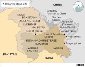
Photo Map Courtesy of BBC News
Background
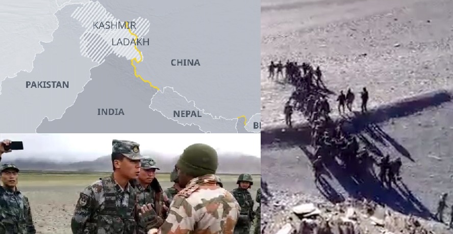
At midnight on June 15, 2020, soldiers from India and China fought a violent and savage confrontation using rocks, fists and clubs made of iron re-bar covered with metal spikes. This vicious conflict took place in the Aksai Chin region in the Galwan Valley. Twenty Indian soldiers were killed in the battle and 76 more were injured. China will not disclose how many of its soldiers were killed or injured by Indian combatants. News agencies and intelligence services estimate a proportionate number of Chinese soldiers were killed; it is possible 43 PLA died in combat. The area where skirmishes took place is controlled by China but claimed by India. Geo-spatial Intelligence sources confirm that China was operational in the area moving heavy military equipment and building tracks in disputed territory. Other questions remain; why would two professional armies with nuclear weapons engage in hand to hand combat using improvised weapons? This is because India and China have signed a series of border agreements to reduce aggression by banning firearms and explosives within 2km of the Line of Actual Control. An exception is made for military exercises, which allows for limited range weapons. The Sino-Indian border dispute is one of complexity and goes back to the 1800s. India recognizes the boundary known as the “McMahon Line” established during the British colonial era. China instead prefers “Borders of Habit,” that existed between adjoining peoples for decades. At the conclusion of the 1962 Sino-Indian border war, a Line of Actual Control (LAC) emerged between China & India. Because the two nations still disagree where one country begins and the other finishes, there is tension over the status quo of the borders. Both nations accuse one another of occupying areas which do not belong to them and have strategic military and economic importance. China needs strong lines of communications with Pakistan a key trading partner, for the belt and road initiative. China has invested 60 Billion dollars on the economic corridor with Pakistan. Last year India finished a new all weather road that runs uncomfortably close to the LAC and China’s’ interests. This road is linked to an Indian airbase the highest in the world. Indian Air force base at Daulat Beg Oldi is a key supply line that supports Indian troops stationed on the Sino-Indian border and the LAC. China is concerned about India’s revocation of (the special status) and how India is now looking at Ladakh strategically. Any Indian expansion or significant fortification of its hold over the region could threaten China’s geostrategic goals in central Asia. China has between 1,200 and 1,500 fighting personnel in the immediate vicinity of the LAC, with around 5,000 more diverted to the region as support. The Peoples Liberation Army has three border-defense companies based close to Aksai Chin. Two companies are drawn from the 362nd Border Regiment and the other company comes from the 363rd Border Regiment. There is also a patrol boat squadron on Pangong Lake, amounting to around 500–600 personnel. Chinese Border Defense Regiments’ operational reserves have also been deployed to the area, raising the total PLA border forces in the area to 1,000–1,500 personnel. In addition to the border forces, the PLA Army has mobilized additional conventional combat forces, most likely from the 6th Mechanized Division. China has a combination of heavy armor and towed artillery deployed in reserve. There have been reports that China has deployed J-20 long-range fighter jets and several other key assets in strategically located Hotan airbase which is around 310 kms from eastern Ladakh. In response to the initial clashes, India has reinforced the Indo-Tibetan Border Police and rotational army units in its forward positions along the LAC with additional army personnel from, the 3rd Infantry Division, Elements of the division’s 81st Mountain Brigade and 114th Infantry Brigade have reportedly been brought forward from their regular cantonments in the valley between Durbuk and Tangtse. Additional units are being brought into theater to replace these mobilized forces as an operational reserve. India has deployed its specialized high altitude warfare forces along the 3,488 km Line of Actual Control (LAC) to repel any transgression by the PLA. In the broader region reserve forces along the border, India and China have a similar number of soldiers along the border, a little over 200,000 each. It is understood that Indian specialized forces trained over the past decades for fighting on the northern front have been pushed up to the frontier. Indian mountain troops are trained in guerrilla warfare and fighting in high altitude which was demonstrated during the Kargil War. In the last three months, the Indian Air Force deployed, almost all its front-line fighter jets Sukhoi 30 MKI, Jaguar and Mirage 2000 aircraft in the key frontier air bases in eastern Ladakh and elsewhere along the LAC. The IAF has deployed Apache attack choppers as well as Chinook heavy lift helicopters.
Analysis
What is clear about the Indian-Sino border tensions is that, strategically China needs clear access routes to Pakistan for its belt and road initiative, and China sees any Indian infrastructure development in the disputed territories as a threat to the security and stability of a key link to Chinese ambitions of regional power and economic dominance. India a regional superpower in its own right will continue to hold the ground in order to protect Indian sovereignty and influence. Indian-Chinese militarization of the border region will persist as it has over the last two centuries, and the pace and scope of military infrastructure development and lines of communication will continue to advance as it is apparent, which ever nation holds, develops and improves the ground it occupies, dictates where border lines exist and what country actually holds regional autonomy.
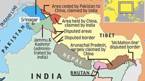
Photo Map Courtesy of Kashmir Watch
Video of hand to hand skirmish combat
Video Indian Chinese Soldiers Deadly Skirmish Courtesy of TOI & YouTube
The Event,
What Happened?
- Without firing a single shot, Indian and Chinese soldiers recently engaged in a bloodbath in the Galwan Valley
- The scuffle between the two nuclear-armed nations in the disputed Himalayan border region led to the deaths of at least 20 Indian soldiers
- It is unclear if or how many Chinese soldiers died (SCMP, 2020)
- Soldiers from the two nations used, rocks, clubs and fists in close combat
- This is the deadliest violence between the two countries over border tensions, in 45 years
- Both sides have accused the other of overstepping the de facto border, the Line of Actual Control (LAC) that runs along the western sector of the valley
- The details of the encounter remain confused, and may never be fully clear (CNN, 2020) (CTV News, 2020)
When Did the Border Clash Happen?
- Midnight on June 15, 2020
Where Did the Border Clash Happen?
- In the he disputed Border lands of India and China at the Line of Actual Control, in the Galwan Valley, close to Aksai Chin, an area controlled by China but claimed by both India and China (CTV News, 2020)
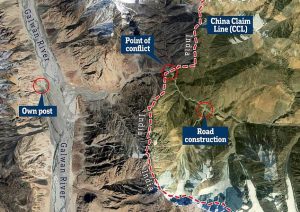
Photo Map Courtesy of Trends Wide
Who Started The Clash?
- India and China have blamed each other for the melee and staked fresh claims on the area where it occurred (CNN, 2020)
What is India Saying?
- Indian security officials said the 20 fatalities were caused by severe injuries and exposure to subfreezing temperatures (CTV, 2020)
- At least 76 Indian soldiers were injured (BBC, 2020)
- India states that China had provoked the fight when Chinese soldiers “sought to erect structures just across the LAC” on the Indian side, and Indian soldiers foiled the attempts
- India claims China has recently begun amassing troops in the LAC and venturing deeper into the contested area of the Line of Actual Control (SCMP, 2020)
What is China Saying?
- China has not commented whether it suffered any casualties in the clash
- (Chinese) Government sources revealed to media that the Chinese side suffered “proportionate casualties” but it does not have a clear picture of the number of Chinese soldiers killed as well as those injured in the clash (Eurasian Times, 2020)
- Chinese foreign ministry spokesperson Zhao Lijian said Wednesday that the confrontation occurred on China’s side of the Line of Actual Control, and that Indian forces had illegally entered Chinese territory (CTV News, 2020) (CNN, 2020)
What are the Intelligence Community & News Outlets Saying About Chinese Casualties?
- Sources in the Indian government are citing ‘some’ US intelligence reports which claim that 35 Chinese soldiers were killed during the violent clash with the Indian army. The figure, however, is a combination of a total number of soldiers killed and wounded (Eurasian Times, 2020)
- India Today journalist Rajdeep Sardesai wrote that ANI (news) claimed based on “Chinese intercepts” that “43 Chinese soldiers [were] killed in the clashes”. He further wrote that there hasn’t been any confirmation from the Chinese side (Eurasian Times, 2020)
Who is Really to Blame for the Deadly Skirmish?
Maxar Satellite Images
- Satellite images from Maxar Images, show military construction had expanded up the Galwan Valley toward the Line of Actual Control from Chinese bases
- Convoy after convoy of Chinese heavy trucks, diggers, bulldozers and some military armored equipment” rolled down the Galwan Valley toward the disputed border (CTV News, 2020) (CNN, 2020)
HawkEye 360 Geospatial Intelligence
- Hawkeye 360 confirms what Maxar is saying
- According to Chris Biggers, a senior analyst with Hawkeye 360, China was moving construction equipment, soldiers and military hardware toward the LAC, before and after the clash
- The Chinese were obviously pushing toward the junction and what they perceive as their claim line
- Biggers states the Chinese have now built a post and a track reinforcing their claim, thus changing the status quo in the area
- At that junction, the Galwan River turns west toward an important supply route for a key Indian airfield Hawkeye 360 satellite imagery shows that India has built a stone wall there facing the new Chinese post, with a layered set of barriers draped in camouflage netting and tarps that Biggers says “could also function as fighting positions” (CTV News, 2020) (CNN, 2020)
Why Does the Darbuk-Shyok-Daulat Beg Oldie (DSDBO) Road Matter?
South China Morning Post
- The Galwan River is the highest ridge line and overlooks the Darbuk-Shyok-Daulat Beg Oldie road, (DSDBO) posing a direct threat to the highway’s security
- By controlling this area China can keep India’s claims on the Aksai Chin plateau in check (SCMP, 2020)
Economic Times of India
- The 255-km Darbuk-Shyok-Daulat Beg Oldie (DSDBO) road joining Leh to the Karakoram Pass, has become a thorn in China’s flesh
- India has been building the road for around two decades and is expected to be completed by this year, the road from Darbuk traverses at an altitude of 14,000 feet and reaches Shyok, the last Indian village in the region (Economic Times of India, 2020)
- Between Shyok and Karakoram Pass (that divides Ladakh from China’s Xinjiang province) lies DBO, (Daulat Beg Oldi [also Oldie, DBO]) is a historic campsite and current Indian military base located in Ladakh) an Indian controlled plateau at an altitude of over 16,000 feet and the location of an Advanced Landing Ground used by the Indian air force to drop supplies
- DBO is India’s northernmost corner, and building a road here has been of vital importance to India
- DBO is located only 9 km away from the Line of Actual Control with China and the road will help manage the border and the areas adjoining Aksai Chin, Chip Chap River and Jiwan Nalla
- It will also ensure faster deployment of troops in the area
- Before the laying of the road, the only way to reach the area was via the Advanced Landing Ground, where heavy-lift aircraft, such as the C-130J, can land (Economic Times of India, 2020)
- From the DSDBO road, a road branches off towards Galwan Valley, a hill feature, which India wants to protect because it overlooks the area around the main road
- The branch road has prompted the stand-off in Galwan Valley
- Indian troops have been patrolling up to this area, but the idea now is to have a road access and presence here
- China has objected to this and doesn’t want India to utilize the DSDBO road to its full potential, which has led to the ongoing confrontations (Economic Times of India, 2020)
Why is this Border Dispute Happening?
- China and India have a complex long standing border dispute, which goes back as far as the 1800s
- At the conclusion of the 1962 Sino-Indian border war, a Line of Actual Control (LAC) emerged
- The LAC is a poorly defined and confusing de facto Border
- India recognizes the ‘McMahon line,'” a holdover of the British colonial era
- China never formally accepted it, opting instead for the ‘borders of habit’ that had existed between adjoining peoples for decades previous
- This created an uneasy status quo which persists today, where neither side quite agrees on the border, both regularly accuse the other of overstepping it or seeking to expand their territory, and excuse for conflict is easy to come by (CNN, 2020)
Where are the Confrontations Happening?
The most recent confrontations between Indian and Chinese border troops have taken place in four main points along the LAC
- Pangong Lake
- The Galwan River valley
- The Hotsprings/Gogra area along the Ladakh border
- Areas near Naku La in Sikkim (DW, 2020)
What are the Tensions About?
- According to Harsh V. Pant, a professor of International Relations at King’s College, London, tensions stem from India’s revocation last year of the special status granted to Jammu and Kashmir, and the splitting of the former Indian state into two territories
- Since then there have been worries in China that India would make life difficult for China going forward
- The region connects China to Pakistan, where they have the economic corridor
- China is concerned about India’s revocation of (the special status) and how India is now looking at Ladakh strategically
- China is worried about India building infrastructure
- The last major crisis in the region, a months-long standoff over the disputed territory of Doklam in 2017, was also related to infrastructure building
- Earlier it mainly used to be on the Chinese building infrastructure, but now India has been ramping up infrastructure along its side of the border, this is upsetting China
- Any Indian expansion or significant fortification of its hold over the region could threaten China’s geostrategic goals in central Asia, said Happymon Jacob, an associate professor at the Center for International Politics, Organization and Disarmament at Delhi’s Jawaharlal Nehru University
- China has invested more than $60 billion on the economic corridor with Pakistan
- This is a “crucial element” of President Xi Jinping’s signature Belt and Road trade and development plan
- Last year, India finished a new all-weather road that runs very close to the Line of Actual Control
- The purpose of this road is to support troops along the border, allowing them to be resupplied by road from Daulat Beg Oldi, the world’s highest airfield
- This would be a major help if India were to further reinforce its position or build out army installations on the border
- Some signs suggest China’s recent advances are a response to the new road, which they perceive as a change in the status quo at the LAC, according to Aidan Milliff, an expert on political violence and South Asia at the Massachusetts Institute of Technology
- “The status quo is actually tolerable to both countries — or at least, their distaste for the status quo is not so much that they will pay the cost of fixing it,” he added. “It’s still not clear to me, as a general principle, whether these disputes start as carefully calculated provocations or as missteps and misunderstandings” (CNN, 2020)
What Military Units are Located in the Region?
Caveat-Troop Levels are intermittently changing & therefore may present gaps in analysis
Chinese Military Units
- Indian media indicates that, by the end of May, China had between 1,200 and 1,500 personnel in the immediate vicinity of the LAC, with around 5,000 more diverted to the region as support
- The Peoples Liberation Army has three border-defense companies based close to Aksai Chin
- Two companies are drawn from the 362nd Border Regiment
- The other company comes from the 363rd Border Regiment
- There is also a patrol boat squadron on Pangong Lake itself
- These units would amount to around 500–600 personnel
- Chinese Border Defense Regiments’ operational reserves – have also been deployed to the area, raising the total PLA border forces in the area to 1,000–1,500 personnel
- In addition to the border forces, the PLA Army has mobilized additional conventional combat forces, most likely from the 6th Mechanized Division. This formation is based far to the northwest, on the southern boundary of the Taklamakan Desert, but constitutes the Southern Xinjiang Military District’s primary operational reserve
- In the Doklam confrontation of 2017, PLA Army force dispositions seemed to follow a similar pattern, with border forces on the front-line, but with regular manoeuvre formations deployed further back as a reserve (IISS, 2020)
Chinese Military Hardware
- China has a combination of heavy armor and towed artillery deployed in reserve (IISS, 2020)
- There have been reports that China has deployed J-20 long-range fighter jets and several other key assets in strategically located Hotan airbase which is around 310 kms from eastern Ladakh (Times of India, 2020)
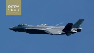
Chinese J20 Fighter Screenshot Courtesy of CCTV News & YouTube

Chinese PLA Type 99 Tank Screenshot Courtesy of US Military Defense & YouTube
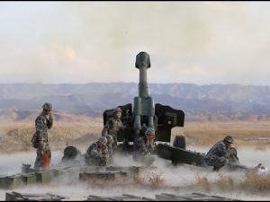
Chinese Artillery Piece Screenshot Courtesy of YouTube
Indian Military Units
In response to the initial clashes, India has reinforced the Indo-Tibetan Border Police and rotational army units in its forward positions along the LAC with additional army personnel from,
- The 3rd Infantry Division
- Elements of the division’s 81st Mountain Brigade and 114th Infantry Brigade have reportedly been brought forward from their regular cantonments in the valley between Durbuk and Tangtse
- Additional units are being brought into theater to replace these mobilized forces as an operational reserve (IISS, 2020)
- India has deployed its specialized high altitude warfare forces along the 3,488 km Line of Actual Control (LAC) to repel any transgression by the Chinese People’s Liberation Army (PLA) in western, middle or eastern sectors (Hindustan Times, 2020)
- In the broader region reserve forces along the border, India and China have a similar number of soldiers along the border, a little over 200,000 each (Hindustan Times, 2020)
- Top government sources confirmed that the Indian Army has been directed to safeguard the LAC from any cross-border aggression by the PLA
- It is understood that specialized forces trained over the past decades for fighting on the northern front have been pushed up to the frontier
- Unlike the PLA which moves in infantry combat vehicles and paved metaled roads, Indian mountain troops are trained in guerrilla warfare and fighting in high altitude which was demonstrated during the Kargil War (Hindustan Times, 2020)
- At the LAC in eastern Ladakh, India has well over 15,000 deployed in forward areas (Times of India, 2020)
Indian Military Hardware
In the last three months, the Indian Air Force deployed, almost all its front-line fighter jets
- Sukhoi 30 MKI
- Jaguar and Mirage 2000 aircraft in the key frontier air bases in eastern Ladakh and elsewhere along the LAC
- The Indian Air Force (IAF) carried out night time combat air patrols over the eastern Ladakh region in an apparent message to China that it was ready to deal with any eventualities in the mountainous region
- The IAF has also deployed Apache attack choppers as well as Chinook heavy lift helicopters (Times of India, 2020)
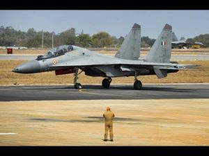
Indian Air Force Sukhoi-30 MKI Screenshot Courtesy of YouTube
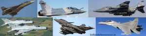
Indian Air Force Sukhoi, Rafale, Jaguar & Mirage Fast Air Screenshot Courtesy of YouTube
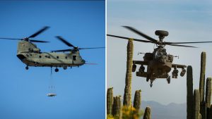
Chinook & Apache Helicopters Screenshot Courtesy of YouTube
The Experts; Tipping the Balance, What is the Conflict Catalyst?
Henry Boyd, analyst with the International Institute for Strategic Studies
- According Boyd; India felt the need to make a military move to prevent China from finishing a road that would allow China to flow forces into the region at a rate that India could not match sufficiently, giving China a strategic advantage down the line (DW, 2020)
Frank O’Donnell of the US Naval War College
- India is far from being in a position of military preponderance. Indian defense officials point to the “touch and go nature” of the mountain environment means a numerical advantage in men and aircraft can be wiped out by inclement weather
- China keeps most of its military firepower along its Pacific coast and would almost certainly redeploy to go for a “round two,” warns O’Donnell
- O’Donnell thinks China’s greater border aggression is a general trend evident in its behavior with all its neighbors and not just about India. (Hindustan Times, 2020)
Taylor Fravel, Professor MIT
- Taylor Fravel, an MIT professor who has written on China’s border policies, says that “China has just over 10 percent of its ground forces [in its western theatre], a very large part of the country, and not even all these troops are focused on India
- ” But because China does not want to deploy a large fraction of its forces in Tibet or Xinjiang”
- “I think this disparity in the local balance makes China especially sensitive to changes that improve India’s position”
- Did India’s steady military improvement trigger Beijing? This is harder to ascertain (Hindustan Times, 2020)

Photo Club Weapons-Courtesy of FR24 News
What Weapons are Used in these Deadly Skirmishes by Chinese and Indian Soldiers?
FIREARM BAN
- India and China signed a series of border agreements in 1993, 1996 and 2005. The 1996 agreement sought to reduce aggression by banning firearms and explosives within 2 km of the LAC
- An exception is made for military exercises, which allows for limited range weapons
HAND TO HAND COMBAT-CLUBS, ROCKS & FISTS
- When the Indian soldiers encountered Chinese troops on June 15, both sides attacked each other with bare fists and medieval-looking clubs spiked with nails and wrapped in barbed wire
- A video that circulated online showed how some Indian soldiers died in the fight, while others from falling into the icy river below (SCMP, 2020)

Photo Indian Casualties-Courtesy of FR24 News
Weather Conditions of the Galwan Valley
- Located high in the Himalayas, it is cold and inhospitable, draped in snow with temperatures around freezing, even in summer, the average altitude is 4,200 meters or 14,000 feet (CTV News, 2020)
- The Galwan Valley and the adjoining region experience freezing temperatures for much of the year
- The forbidding conditions are arid and inhospitable
- In addition to altitude challenges the temperature adds further stress to the soldiers’ well-being, with humans unable to withstand prolonged periods in temperatures above 50ºC or below -26ºC, which are common in the region (SCMP, 2020)
How does the Altitude in the Galwan Valley Effect Soldiers Engaged in Mountain Warfare?
Military operations 4,000 metres above sea level represent complex challenges
- The low atmospheric oxygen, low humidity, and strong ultraviolet radiation experienced at high altitudes can induce a number of pathophysiological phenomena, which can lead to disorders of the cardiovascular, respiratory, and ocular systems
- Military operations 4,000 metres above sea level represent complex challenges
- Soldiers need to stop at different heights over several days to acclimatize to the altitude
- Ascending too quickly can put even young and healthy soldiers at grave risk of acute altitude sickness, pulmonary edema, and cerebral edema
- Even after they acclimatize, the speed at which soldiers can move is compromised, as are the loads they can carry, and they need to consume additional calories to remain fit and healthy
- The mildest form of altitude sickness, AMS is produced by a lack of oxygen and can affect anybody
- Symptoms include headache, nausea, vomiting, fatigue, irritability, dizziness and sleep disturbance, and can appear within 3 to 24 hours after ascent
- The incidence and severity vary with the initial altitude, rate of ascent, level of effort, and individual body conditions (SCMP, 2020)
- At almost double the height where altitude sickness kicks in, any humans in the area have to undergo tedious, gradual acclimatization or suffer crippling headaches, nausea and fatigue (CTV News, 2020)
- Most armies follow a template called “graded ascent” to acclimate their soldiers to high altitude, moving soldiers to steadily higher altitudes over a period of up to 10 days. Doing so is critical for preventing combat power degradation from altitude sickness (War on the Rocks, 2020)
What About Fighting at High Altitude?
Even shooting is harder
- The Indian Army learned during the Kargil war in 1999 that rifle rounds and artillery shells fly differently at high altitudes
- Artillery batteries need altitude-specific firing tables to put shells on their intended targets, and infantry soldiers need to re-sight weapons and practice in the thin air
- At the extreme heights in Ladakh and Sikkim, soldiers’ eyesight changes
- Low air pressure can induce corneal distortion (causing nearsightedness), diminish low-light vision, and degrade depth perception (War on the Rocks, 2020)
- The art of mountain fighting is the toughest
- The troops from Uttarakhand, Ladakh, Gorkha, Arunachal and Sikkim have adapted to the rarefied heights over centuries and hence their capability of fighting in close quarter combat is without match, the artillery and the missiles need to have pin-pointed accuracy or else they miss the mountain target by miles,” said a former Indian Army chief (Hindustan Times, 2020)
- Once the need for more forces at the border is identified, neither army can do much to expedite movement past the rate dictated by graded ascent unless they are willing to accept substantial non-combat attrition in improperly acclimatized units
- Travelling lighter and in smaller groups may speed mobilization in normal operations, but there is no shortcut for acclimatization. (War on the Rocks, 2020)
High Altitude Terrain, Military Strategies & Combat Conditions
Aidan Milliff Ph.D. Candidate in Political Science at the MIT comments about the border dispute between China & India for War on the Rocks,
- Conditions during winter — bitterly cold with heavy snow — can make much of the area inaccessible, meaning the window for manoeuvres is very slim
- Even during summer, when conditions are better, the altitude, weather and temperatures make everything more difficult (War on the Rocks, 2020)
- Operating above 4,000 meters, as both the Indian Army and the PLA are well aware, changes nearly every aspect of warfare
- Soldiers take days to acclimatize to any altitude above 2,400 meters
- Reinforcements deployed to altitude will be slower than the speed of their transport
Everything suffers at this altitude
- Diesel engines struggle to operate, helicopters have to cut their loads, and the amount of supplies required to keep troops healthy is far higher
- Even if altitude were not a factor, the terrain along the India-China border would still complicate military operations
- The Himalayan Plateau is not flat like the central front in Europe, nor necessarily tank-drivable like the deserts in Iraq or along the border between western India and southern Pakistan (War on the Rocks, 2020) (CTV News, 2020)
About the History of the Disputed Region
- Aksai Chin is part of greater Kashmir, and after the bloody war between Pakistan and India in 1947 resulted in the partition of that region, the border between China and India was left ill-defined
- India claims the region as part of Ladakh, a remote, mountainous territory in the eastern Kashmir valley which was until last year part of the Indian-controlled but semi-autonomous state of Jammu and Kashmir, the part of the wider disputed region that ended up in Indian control following the 1947 war with Pakistan
- “While India recognized the so-called ‘McMahon line,'” a holdover of the British colonial era, analyst Larry Wortzel writes in a US military report, “China never formally accepted it, opting instead for the ‘borders of habit’ that had existed between adjoining peoples for decades previous”
- This created an uneasy status quo which persists today, where neither side quite agrees on the border, both regularly accuse the other of overstepping it or seeking to expand their territory, and excuse for conflict is easy to come by (CTV News, 2020)

Resources
What’s behind China and India’s border dispute in the Himalayas? DW-Ole Tangen Jr (2020) https://www.dw.com/en/whats-behind-china-and-indias-border-dispute-in-the-himalayas/av-54082025
India Strengthens Military Presence in All Strategic Points in Pangong Lake Area-Times of India-Staff Writers (2020) https://timesofindia.indiatimes.com/india/india-strengthens-military-presence-in-all-strategic-points-in-pangong-lake-area-sources/articleshow/77853539.cms
Understanding the military build-up on the China–India border-International Institute for Strategic Studies-Meia Nouwens & Henry Boyd (2020) https://www.iiss.org/blogs/analysis/2020/06/china-india-border
India has closed military gap with China along border-Hindustan Times -Pramit Pal Chaudhuri (2020) https://www.hindustantimes.com/opinion/india-has-closed-military-gap-with-china-along-border/story-aMltn7t0MQWqdagqdXoBEJ.html
India deploys specialised mountain forces to check China’s LAC transgressions-Hindustan Times-Shishir Gupta (2020) https://www.hindustantimes.com/india-news/india-deploys-specialised-mountain-forces-to-check-china-s-transgressions-along-lac/story-ABqjJToNSziO1QGfsCtPOI.html
India-China standoff: Forces on almost war-like alert along LAC, ready to ‘impose costs’ on China-Times of India-Rajat Pandit (2020) https://timesofindia.indiatimes.com/india/india-china-standoff-forces-on-almost-war-like-alert-along-lac-ready-to-impose-costs-on-china/articleshow/76433796.cms
Why are China and India fighting over an inhospitable strip of the Himalayas?-CNN-James Griffiths (2020) https://www.cnn.com/2020/06/17/asia/india-china-aksai-chin-himalayas-intl-hnk/index.html
In making for two decades, DSDBO road now upsets China-The Economic Times- Shaurya Karanbir Gurung-(2020) https://economictimes.indiatimes.com/news/defence/in-making-for-two-decades-dsdbo-road-now-upsets-china/articleshow/76250295.cms
Galwan Valley: India and China downplay reports of soldier release-BBC News-Staff Writers (2020) https://www.bbc.com/news/world-asia-53102629
SOUTH ASIAFACT CHECK: 100 Chinese Soldiers Killed In India-China Border Clash At Galwan Valley? –Eurasian Times-Eurasian Times Staff (2020) https://eurasiantimes.com/fact-check-100-chinese-soldiers-killed-in-india-china-border-clash-at-galwan-valley/
Satellite images show build up at site of deadly India-China border clash-CTV News-Brad Lendon and Maneeva Suri (2020) https://www.ctvnews.ca/world/satellite-images-show-buildup-at-site-of-deadly-india-china-border-clash-1.5001070
Images
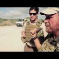
Cover Photo Image Courtesy of Mera Mirpur News (2020) http://www.meramirpur.com/20-indian-soldiers-killed-in-hand-to-hand-combat-with-chinese-soldiers-at-galwan-river-valley/
Photo Map Image Courtesy of Trends Wide (2020) https://trendswide.com/china-has-already-diverted-galwan-river-to-claim-more-territory-on-border-with-india-claim-experts/
Photo Map Courtesy of BBC News (2020) https://www.bbc.com/news/world-asia-52852509
Photo Map Courtesy of Kashmir Watch (2020) https://kashmirwatch.com/sino-india-border-tensions-intensify/
Photo Map Courtesy of CNN (2020) https://www.cnn.com/2020/06/17/asia/india-china-aksai-chin-himalayas-intl-hnk/index.html
Photo Map Courtesy of ABC (2020) https://www.abc.net.au/news/2020-06-17/what-is-behind-the-india-china-border-dispute-lac/12363348
Screen Shot Courtesy of YouTube-J20 Fighter https://www.youtube.com/watch?v=VyCagF0RUQQ
Screen Shot Courtesy of YouTube-Type 99 Tank China https://www.youtube.com/watch?v=qUQCoD56Zpk
Screen Shot Courtesy of YouTube-Chinese Artillery https://www.youtube.com/watch?v=sDNIVHmQork
Screen Shot Courtesy of YouTube-Sukhoi-30-MKI https://www.youtube.com/watch?v=3q-1s-7hJqA
Screen Shot Courtesy of YouTube-Indian Fast Aircraft http://www.indiandefensenews.in/2020/06/sukhoi-su-30mkis-dassault-rafale-tejas.html
Screen Shot Courtesy of YouTube-Helicopter Apache & Chinook https://www.thequint.com/news/india/boeing-delivers-37-apache-and-chinook-helicopters-indian-air-force-details
Photo Club Weapons-Courtesy of FR24 News (2020) https://www.fr24news.com/a/2020/06/chinese-troops-mutilated-the-corpses-of-20-indian-soldiers-with-horrible-studded-clubs-after-a-melee-shot.html
Photo Indian Casualties-Courtesy of FR24 News (2020) https://www.fr24news.com/a/2020/06/chinese-troops-mutilated-the-corpses-of-20-indian-soldiers-with-horrible-studded-clubs-after-a-melee-shot.html